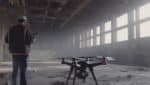
Drone-based 3D modeling and photogrammetry have revolutionized the way we capture and analyze spatial data. By combining high-resolution aerial imagery with advanced software, drones can create accurate and detailed 3D models of various objects, terrains, and structures. In this article, we will explore the applications of drone-based 3D modeling and photogrammetry, as well as best practices for achieving optimal results.
1. Applications of Drone-based 3D Modeling and Photogrammetry
a. Construction and Architecture
Drone-based 3D modeling and photogrammetry are valuable tools in the construction and architecture industry. By capturing aerial imagery and generating 3D models of construction sites and buildings, stakeholders can visualize and analyze project progress, identify potential issues, and improve communication among team members. Drones can also assist in site surveying, topographic mapping, and generating as-built models for accurate documentation.
b. Real Estate and Property Management
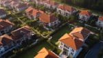
For real estate professionals and property managers, drone-based 3D modeling and photogrammetry offer a unique way to showcase properties. High-resolution aerial imagery and 3D models provide potential buyers or tenants with a comprehensive view of the property’s layout, surroundings, and features. This technology can also be used for property inspections, identifying maintenance needs, and assessing property values.
c. Archaeology and Cultural Heritage
Drones have become valuable tools for archaeologists and cultural heritage professionals. By capturing detailed aerial imagery and creating 3D models of archaeological sites, historical buildings, or artifacts, experts can better document, analyze, and preserve cultural heritage. Drone-based 3D modeling allows for non-invasive data collection and enables virtual reconstructions, enhancing research and public engagement in archaeology.
d. Environmental Monitoring and Conservation
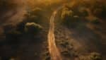
Drone-based 3D modeling and photogrammetry are crucial for environmental monitoring and conservation efforts. By capturing aerial imagery and generating 3D models of ecosystems, drones can assess biodiversity, monitor habitat changes, and aid in conservation planning. This technology also plays a role in mapping and monitoring areas affected by natural disasters, tracking land degradation, and managing natural resources.
e. Surveying and Mapping
Drones equipped with photogrammetry software are transforming the surveying and mapping industry. By capturing aerial imagery and generating accurate 3D models, drones can quickly survey large areas, map terrain, and create topographic maps. This technology offers a cost-effective and time-efficient alternative to traditional surveying methods, allowing professionals to gather precise data for various applications, including urban planning, infrastructure development, and land management.
2. Best Practices for Drone-based 3D Modeling and Photogrammetry
a. Plan and Prepare
Before conducting a drone-based 3D modeling and photogrammetry project, it is essential to plan and prepare. Define the project objectives, identify the area to be mapped, and assess any potential risks or restrictions. Ensure compliance with local regulations and obtain necessary permits or authorizations. Plan the flight path, considering factors such as altitude, overlap between images, and lighting conditions. Conduct a thorough pre-flight inspection of the drone and equipment to ensure safe and accurate data collection.
b. Choose the Right Equipment
Selecting the appropriate drone and camera equipment is crucial for successful 3D modeling and photogrammetry. Consider factors such as camera resolution, sensor size, and image quality. Opt for a drone that can carry the necessary payload and has stable flight capabilities. High-quality cameras and sensors will ensure accurate data capture and better image resolution for generating precise 3D models.
c. Optimize Image Capture
To generate accurate 3D models, it is essential to optimize image capture during the flight. Fly the drone in a grid or zigzag pattern to ensure adequate overlap between images. Maintain a consistent altitude and speed throughout the flight. Avoid extreme angles and obstructions that may affect image quality. Capture images during optimal lighting conditions to minimize shadows and improve image clarity.
d. Use Specialized Photogrammetry Software
To process the aerial imagery and generate 3D models, specialized photogrammetry software is required. Choose reputable software that offers robust processing capabilities, accurate reconstruction algorithms, and user-friendly interfaces. Familiarize yourself with the software’s settings and features to maximize the quality of the 3D models. Be prepared for significant computational requirements, as processing large datasets can be time-consuming and resource-intensive.
e. Post-Processing and Quality Control
After generating the 3D models, it is essential to conduct post-processing and quality control checks. Inspect the models for any artifacts, inaccuracies, or missing data. Validate the accuracy of the models by comparing them with ground control points or reference data, if available. Adjust the models as needed, ensuring alignment with real-world coordinates. Finally, export the models in the desired format for further analysis or visualization.
Conclusion
Drone-based 3D modeling and photogrammetry have revolutionized various industriesby providing a powerful and efficient way to capture and analyze spatial data. The applications of this technology are vast, ranging from construction and architecture to archaeology, environmental monitoring, and surveying. By following best practices such as careful planning, selecting the right equipment, optimizing image capture, using specialized software, and conducting post-processing and quality control checks, professionals can achieve accurate and detailed 3D models. As drone technology continues to advance, the capabilities of drone-based 3D modeling and photogrammetry will only expand, providing even more opportunities for innovation and problem-solving in various fields.